since 2010
What Can We Offer

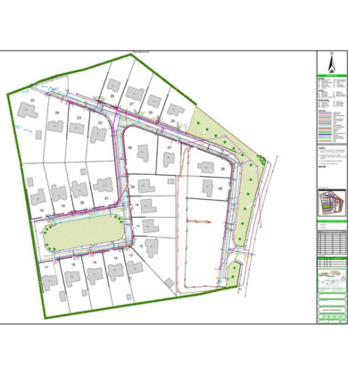
Topographic Surveying
Accurate topographical, boundary, and layout surveys using total stations, drones, and GPS technology. Essential for project planning, approvals, and legal documentation.
Topographic surveying captures the natural and man-made features of a piece of land, including elevation and contours, for design and planning purposes.
Key Features of Our Topographic Surveying Services:
Topographic surveying ensures that your project is built on reliable, precise, and actionable data, supporting safe, efficient, and well-planned development. By providing a clear understanding of the site’s features and constraints, we help clients make informed decisions and optimize design and construction processes.

Boundary Surveys
Boundary surveys are essential for defining the precise legal limits of a property, helping landowners, developers, and authorities establish clear ownership and avoid disputes. Accurate boundary surveys are critical for property transactions, construction planning, and legal compliance.
Our team uses modern surveying tools such as total stations, GPS, and GIS technology to identify property corners, demarcate boundary lines, and provide certified survey documents that are legally recognized.
Key Features of Our Boundary Survey Services:
Boundary surveys provide a solid foundation for legal, planning, and construction purposes, ensuring that property limits are accurately defined and all development activities proceed without legal or structural conflicts.
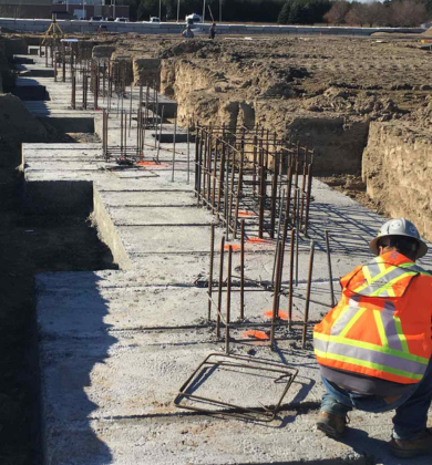
Construction Layout Surveys
Construction layout surveys are essential for translating design plans into precise on-site locations. They guide the accurate placement of buildings, roads, utilities, and other infrastructure, ensuring that the construction aligns perfectly with architectural and engineering designs.
Our team uses advanced surveying equipment such as total stations, GPS, and laser levels to mark exact positions, verify alignments, and provide reference points for contractors. This precision helps avoid errors, minimize rework, and maintain project timelines.
Key Features of Our Construction Layout Survey Services:
Construction layout surveys ensure that your project is built accurately, efficiently, and safely, serving as a critical step between design and construction for successful execution.

Land Subdivision Surveys
Land subdivision surveys are essential for dividing a large property into smaller, well-planned lots for residential, commercial, or industrial development. These surveys ensure that each parcel is accurately measured, properly allocated, and legally compliant with local zoning and land-use regulations.
Our services combine precision surveying techniques, legal compliance, and design considerations to create subdivision layouts that optimize land use, provide proper access, and facilitate smooth development.
Key Features of Our Construction Layout Survey Services:
Land subdivision surveys provide a solid foundation for property development, legal compliance, and infrastructure planning, ensuring that land is efficiently utilized, properly documented, and ready for construction or sale.

Contour Mapping
Contour mapping is a critical surveying service that represents the elevation, slope, and shape of the land on a map. It provides a visual understanding of terrain features, allowing engineers, architects, and planners to make informed decisions for construction, landscaping, and infrastructure projects.
Our contour mapping services utilize advanced surveying tools such as GPS, total stations, and drones to capture accurate elevation data, helping to optimize land grading, drainage, and overall project planning.
Key Features of Our Construction Layout Survey Services:
Contour mapping provides a clear and accurate understanding of the land’s topography, supporting efficient, safe, and cost-effective planning and construction. It ensures that projects are designed with proper attention to terrain, drainage, and overall site conditions.
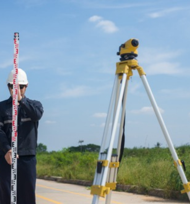
Leveling Surveys
Leveling surveys are a fundamental surveying service used to measure vertical distances and determine precise elevations, establishing gradients and reference levels across a site. Accurate leveling is crucial for infrastructure projects, including roads, drainage systems, pipelines, and building foundations.
By using advanced equipment such as digital levels, total stations, and GPS instruments, our leveling surveys provide reliable elevation data to support precise design, planning, and construction.
Key Features of Our Leveling Survey Services:
Leveling surveys provide the precise elevation and gradient data necessary for efficient, safe, and cost-effective construction. Accurate leveling ensures that infrastructure and buildings are built correctly, with proper slopes, drainage, and site stability.
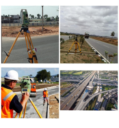
Road and Alignment Surveys
Road and alignment surveys are essential for the planning, design, and execution of transportation and utility corridors, including roads, highways, railways, and pipelines. These surveys determine the most efficient and feasible route by carefully analyzing terrain, elevations, existing features, and environmental constraints.
Our road and alignment survey services ensure accurate horizontal and vertical alignment, enabling smooth transportation flow, structural stability, and long-term performance while minimizing construction costs and environmental impact.
Key Features of Our Road and Alignment Survey Services:
Road and alignment surveys provide a strong foundation for safe, efficient, and sustainable transportation infrastructure, ensuring smooth movement, reduced maintenance, and long-term project success.
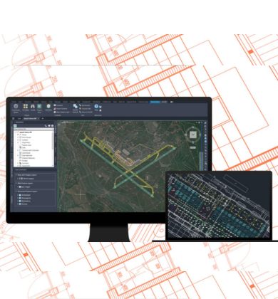
GIS and CAD Integration
GIS and CAD integration combines geographic information systems (GIS) with computer-aided design (CAD) to create accurate, data-driven, and interactive maps for land management, planning, and development projects. This integration allows spatial data and design elements to work together seamlessly, improving precision and decision-making throughout the project lifecycle.
By linking real-world geographic data with detailed design drawings, GIS and CAD integration enhances planning efficiency, visualization, and documentation accuracy for both small-scale and large-scale developments.
Key Features of Our GIS and CAD Integration Services:
GIS and CAD integration delivers high-precision planning, improved visualization, and efficient documentation, supporting smarter land management and successful project execution from concept to completion.

Plot Demarcation
Plot demarcation is the process of physically marking the exact boundaries of a plot on the ground using stakes, markers, stones, or fencing for clear and visible identification. It ensures that landowners, developers, and contractors have an accurate understanding of property limits before construction or land allocation begins.
This service plays a vital role in preventing boundary disputes, ensuring legal compliance, and guiding construction activities within approved property limits.
Key Features of Our Plot Demarcation Services:
Plot demarcation provides a clear physical reference of property boundaries, enabling smooth construction, legal clarity, and efficient land management while safeguarding ownership rights.

Land Development Feasibility Studies
Land development feasibility studies are conducted to evaluate the overall potential and practicality of developing a piece of land. These studies consider environmental conditions, legal regulations, infrastructure availability, market demand, and financial viability to determine whether a proposed project can be successfully implemented.
Our feasibility studies provide stakeholders with clear insights into risks, opportunities, and development constraints, enabling confident and informed decision-making before committing resources.
Key Features of Our Land Development Feasibility Study Services:
Land development feasibility studies help minimize uncertainty and investment risk by providing data-driven insights and practical recommendations, ensuring that land development projects are planned strategically and executed successfully.
As-Built Surveys
As-built surveys are conducted after construction is completed to document the exact location, dimensions, and condition of built structures and site features. These surveys reflect what has actually been constructed on-site, rather than what was originally planned, providing an accurate and reliable record for future reference.
As-built survey data is essential for verifying construction accuracy, ensuring compliance with approved designs, and supporting future maintenance, renovations, or expansions.
Key Features of Our As-Built Survey Services:
As-built surveys provide a true and accurate representation of completed construction, ensuring transparency, compliance, and confidence for owners, developers, and authorities throughout the lifecycle of the project.

Digital Surveying and Drone Mapping
Digital surveying and drone mapping utilize advanced technologies such as UAVs (drones), GPS, and high-resolution imaging to capture accurate spatial data over large and complex areas. This modern approach enables rapid data collection while maintaining exceptional accuracy, making it ideal for infrastructure, land development, and environmental projects.
By integrating drone-captured data with GIS and CAD platforms, digital surveying provides powerful tools for analysis, visualization, and decision-making throughout the project lifecycle.
Key Features of Our Digital Surveying and Drone Mapping Services:
Digital surveying and drone mapping offer a fast, precise, and technology-driven approach to land surveying, enabling smarter planning, improved visualization, and efficient execution of modern development projects.